Southern Coastal Creeks
Marin’s Southern Coastal watersheds include:
- Webb Creek
- Lone Tree Creek
- Cold Stream
- Redwood Creek
- Alder Creek
- Rodeo Lagoon
- Tennessee Valley
Webb Creek
Webb Creek originates at the peaks of Mt. Tamalpais and flows towards the Pacific Ocean through Steep Ravine Canyon and Mt. Tamalpais State Park. The creek drains into the Pacific between Stinson Beach and Rocky Point.
Lone Tree Creek and Cold Stream
North of the community of Muir Beach, Lone Tree Creek and Cold Stream drain the area west of the ridge line that forms the Dipsea and Coastal Fire Roads. They flow through the lands of the Golden Gate National Recreation Area (GGNRA) and into the Pacific Ocean.
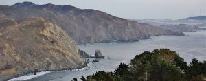
Redwood Creek
The Redwood Creek watershed begins at the peak of Mt. Tamalpais and extends southwest to Muir Beach where it drains into the Pacific Ocean. The watershed encompasses an area of less than 9 square miles. At the mouth of the watershed is Big Lagoon, an intermittent tidal lagoon.
Redwood Creek is one of five global biodiversity “hot spots" recognized in the United States. Its location is also within Golden Gate Biosphere Reserve.
Main tributaries to Redwood Creek include:
- Bootjack Creek
- Fern Creek
- Kent Canyon Creek
- Rattlesnake Creek
- Spike Buck Creek
Alder Creek
Alder Creek drains the western half of the Bolinas Mesa, including most of the town of Bolinas itself. The creek flows into Duxbury Reef and the Pacific Ocean through Agate Beach. Alder Creek is dry from April to November.
To the north, Arroyo Hondo and other smaller tributaries also flow into Duxbury Reef. These are part of Point Reyes National Seashore. The shoreline throughout the watershed is part of the Duxbury Reef Area of Special Biological Significance (ASBS).
Rodeo Lagoon and Tennessee Valley
The southern coastal streams are the Rodeo Lagoon and Tennessee Valley drainages. Their location is north of Point Bonita and south of the Muir Beach community and Coyote Ridge.
These systems flow through the lands of GGNRA and along the western slopes of the Marin Peninsula. Approximately five intermittent streams flow through the 2 square miles of the Tennessee Valley drainage.
Two main drainages flow from the north and south into Rodeo Lagoon near Fort Cronkhite. The Lagoon drains an area of approximately 4 square miles.