For more than a decade, online sea level rise viewers have helped people visualize what future sea level rise may look like. Many online viewers exist with different data sets and geographies, but it can be hard to find one that offers a hyper local look at potential future shoreline flooding in a user-friendly format.
Recognizing this challenge, a group of local electeds and staff leadership from Marin’s cities and towns commissioned County staff to develop a Marin-specific sea level rise viewer that provides consistent sea level rise data to the public.
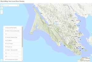
The resulting new Marin Sea Level Rise Viewer is hosted by MarinMap and can be accessed at marinmap.org. Details on this new viewer can be found on the Marin Sea Level Rise Viewer informational webpage created by the Marin County Flood Control & Water Conservation District.
This new viewer uses the same 6 sea level rise scenarios as the Marin Shoreline Vulnerability Assessment to explore near, medium, and long term sea level rise. While the scenarios have not changed and still remain consistent with best available science and current state planning guidance, what is new is how this app allows users to interact with data at a local scale. Thanks to ArcGIS Online web mapping technology, users can pan, zoom in and out, click on items of interest to see pop-ups with additional information, and explore flooding scenarios alongside other datasets like critical local infrastructure and building footprints.
Visit the Marin Sea Level Rise Viewer on MarinMap today and start exploring the future.