Marin Shoreline Vulnerability Assessment

In 2017, Marin County Department of Public Works completed the Marin Shoreline Sea Level Rise Vulnerability Assessment -- a technical report that details how shoreline flooding will worsen with sea level rise if no actions are taken.

The Vulnerability Assessment identifies specific risks and impacts along the entire bay shoreline, from Sausalito to Novato, for six sea level rise scenarios, shown in the table below. These sea level rise scenarios:

  • Were selected using best available science
  • Are consistent with state guidance on sea level rise adaptation planning
  • Model near, mid, and long-term sea level rise with and without added water levels from major storms
  • Include the high tide and storm flooding we already experience in Marin
Sea Level Rise Scenarios
Marin Shoreline Vulnerability Assessment Scenarios Sea Level Rise Sea level Rise + 100-year storm
Near-term (approx. 2030) 10 inches (0.8 feet) 46 inches (3.8 feet)
Mid-term (approx. 2050) 20 inches (1.6 feet) 56 inches (4.7 feet)
Long-term (approx. 2100) 60 inches (5 feet) 96 inches (8 feet)


Sea level rise scenarios

screenshot from CoSMoS sea level rise viewer web interface. Basemap of Marin County with coastline in blue is shown next to slider bards for amount of sea level rise in feet and storm frequency interval in years.
Image from the Our Coast Our Future (OCOF) web platform. Point Blue Conservation Science and U.S. Geological Survey. www.ourcoastourfuture.org (accessed June 2022)

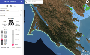
While many sea level rise modeling tools are publicly available, the Bay shoreline Vulnerability Assessment process selected USGS’s Coastal Storm Modeling System (CoSMoS) to model sea level rise impacts countywide. This free tool can be accessed on the Our Coast, Our Future (OCOF) website .

To learn more about the range of available sea level rise models and the scenario selection process for the Vulnerability Assessment, please read this 2015 memo.

Sea level rise is a shared issue—floodwaters do not stop at jurisdictional boundaries. To ensure coordination and consistency across local jurisdictions’ adaptation planning efforts County staff recommend local vulnerability assessments and adaptation plans use the same sea level rise scenarios used in the County’s Marin Shoreline Vulnerability Assessment process.

Reading the Vulnerability Assessment

The Marin Shoreline Vulnerability Assessment doesn’t have to be read all the way through. You can read the Executive Summary for an overview of how the report was developed. Then, you can select the community profiles or asset types below that interest you, to learn about specific locations and impacts.

Close window