What happens when it rains?
Every drop of rain follows a different path downhill. Where it goes depends on how much rain falls, what people have done to modify its route through the watershed, and many other factors. If we understand the causes of flooding, we can begin to address its impacts.
Mount Tamalpais
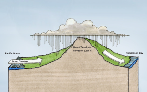
The summit of Mount Tamalpais receives the most rainfall in the county. The watershed is drier at lower elevations near the bay.
From roughly October to April, Mount Tamalpais and its ridges capture storms off the Pacific. An average of 56 inches of rain falls each year at the summit of Mount Tamalpais. Some of the rain seeps into the ground and emerges hours, days, and even months later. Some rain collects in channels and flows towards Richardson Bay and towards the Pacific Ocean.
Downstream, steep slopes give way to broad, flat valleys. On average, only 32 inches of rain fall each year at the mouth of the Mill Valley watershed but rain from the uplands contributes to the flows on the valley floor. During most rainfall events, waterways remain within their channels or underground pipes until they meet the tidewater of Richardson Bay.
Flood types
Learn about different types of floods and response patterns.
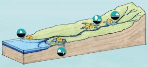
Tidal inundation: when rising tides fill creeks and flood lowlands
Extreme high tide events exacerbate creek or stormwater overflow during storms. High tides can back up stormwater pipes and prevent non-tidal areas from draining. Sea level rise will increase the extent and frequency of tidal inundation.
Stormwater overflow: when stormdrains back up
Stormwater drainage systems quickly convey rainwater through underground pipes to creeks and the Bay. When the stormdrains are obstructed or broken or when the creeks that they lead to are already full, water backs up onto the streets.
Isolated ponding: when pools form on the ground
Isolated ponding can occur in any area that doesn’t drain effectively – for example, in a natural depression in the landscape.
Creek overflow: when creeks spill over their banks
Naturally, waterways regularly overflowed onto an adjacent flood plain. Buildings are now often located on these flood plains. The size and slope of a channel, blockages, proximity to the bay, and constrictions obstructing flow such as bridges, utility pipes, or adjacent buildings all influence the frequency and volume of creek overflow.
Land use impact
Flooding is a problem when it impacts human settlement. How we develop natural lands and how we manage stormwater impacts the ways water interact with our communities.
Natural
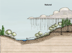
Prior to development, flat lowlands flooded frequently. When rain fell, it infiltrated into the ground and moved slowly toward the creek channel. The ground acted like a sponge, storing water and releasing it slowly. While water moved underground, it was naturally cleansed by physical and biological processes. Annual floods brought life-giving water to parched floodplains, nourishing them with fresh sediment. They recharged aquifers and allowed fish to swim over normally dry land that was rich with food. Tides flooded biologically rich marshes along the bay perimeter twice a day.
Urbanized
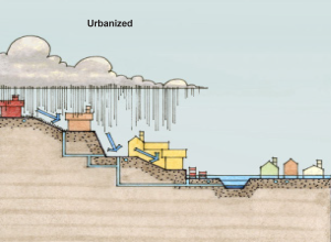
When humans began to develop the land, we created conflicts between what we built and the natural tendency of creeks to flood. Much of the development in Marin was built in flood-prone areas which put it at risk of inundation.
Roads, parking lots, roofs, and other impervious surfaces prevent water from infiltrating the ground. Instead, it moves quickly across the landscape into pipes and creeks further increasing flood risk downstream.
How flooding impacts water quality
Water quality can be impaired by:
- Excessive nutrients
- Pesticides
- Elevated bacterial levels (such as fecal coliform)
- Sediment from erosion
- Sewage spills
Moving water away as quickly as possible can have negative impacts on water quality. Waters that move slowly and have an opportunity to infiltrate can be cleansed by physical and biological processes that naturally occur underground.
Floods can also overwhelm sewage treatment facilities and wash untreated sewage into creeks, move trash into stormdrains, which drains to the bay and ocean. Water from the exteriors of our homes and businesses is not treated and flows directly to creeks, bays, and the ocean.
How climate change and sea level rise affects flooding
Dealing with flooding from rain and upstream runoff is already complicated. Sea level rise will make it even more complicated by increasing the frequency and duration of flooding.
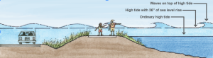
When water temperature increases, water expands and takes up more space than cold water. As the planet warms, the water in the ocean warms, expands, and elevates sea levels. The changing climate has also melted parts of the ice caps at the North and South Poles. As this ice melts and flows into the ocean, it increases the amount of water in the ocean and raises sea levels even more. Sea levels in San Francisco Bay have risen eight inches over the past century.
Predictions of future sea level rise vary from 12 inches by 2030 to 60 inches by 2100. The Bay Conservation and Development Commission (BCDC) recommends using 36 inches of sea level rise for planning purposes.
Rising sea levels increase the upstream extent of tidal flooding, worsen creek overflow due to backwater effects of elevated high tides, and create larger, stronger waves which erode the shoreline and destroy sensitive marshes. Coastal flooding will have a large impact on cities and habitat.